Many construction teams in Anaheim assume uniform subsurface conditions across the city's flat terrain. That assumption often leads to cost overruns or foundation failures. The Santa Ana River corridor and historic alluvial fans create sharp lateral variations in soil stiffness and velocity. Without a seismic tomography survey, these transitions remain invisible. We map P-wave and S-wave velocity profiles using both refraction and reflection methods. This data reveals bedrock depth, fault zones, and loose sand pockets that standard borings miss entirely. For projects near the Anaheim Resort district, we typically pair this with MASW-VS30 to capture shear-wave velocity for site class determination under ASCE 7. The combination delivers a complete picture of seismic behavior before design begins.
Seismic tomography in Anaheim reveals velocity contrasts up to 3:1 across the Santa Ana River alluvial plain, directly impacting site class and liquefaction assessment.
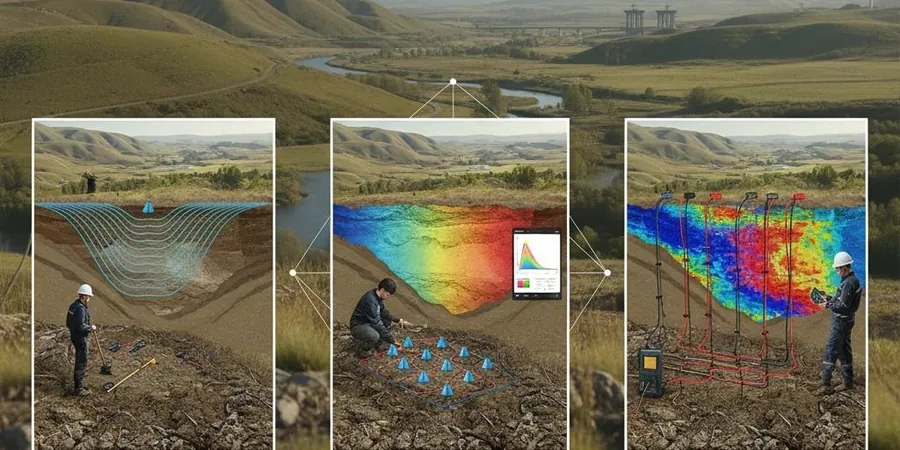
Method and coverage
Anaheim grew rapidly after the 1950s, with much of its development sitting on Quaternary alluvium deposited by the Santa Ana River. These sediments vary from dense gravels near the riverbed to soft silts and clays farther east. Our seismic tomography surveys adapt to this variability. We deploy linear arrays of 24 to 48 geophones with source offsets up to 200 meters. The refraction method resolves shallow velocity layers down to 30 meters, while reflection imaging targets deeper structures like the Newport-Inglewood fault zone's northern extension. We process data using first-arrival picking and full-waveform inversion. Before mobilizing, we often integrate resistivity surveys to correlate velocity changes with lithological boundaries. This dual-geophysical approach reduces drilling costs by targeting only critical borehole locations.
Technical reference image — Anaheim
Regional considerations
The difference between Anaheim Hills and the flatlands near the 91 freeway is not just elevation. Bedrock in the hills sits 5 to 15 meters below grade, while downtown Anaheim's alluvium extends past 40 meters. Shallow bedrock amplifies ground motion during earthquakes. Deep alluvium, on the other hand, increases liquefaction potential. We have seen projects in the Platinum Triangle area underestimate these contrasts, leading to redesigns mid-construction. A seismic tomography survey quantifies the transition zone. It tells you exactly where the velocity jump occurs and how sharp it is. That information directly impacts foundation type, pile depth, and seismic detailing requirements under IBC Chapter 16.
First-arrival traveltime inversion for near-surface velocity modeling. Ideal for bedrock mapping, rippability assessment, and void detection. We achieve sub-meter resolution in the upper 30 meters using dense geophone spacing.
02
Multi-channel Reflection Imaging
Common-depth-point (CDP) stacking with high-fold coverage for deep structural targets. Applied for fault mapping, stratigraphic delineation, and deep foundation planning. Typical fold reaches 12–24 in Anaheim's alluvial environment.
Standards that apply
ASTM D5777-18 (Standard Guide for Seismic Refraction), ASTM D4428/D4428M-14 (Crosshole Seismic Testing), ASCE 7-22 Section 11.4 (Site Class Determination)
Quick answers
How deep can seismic tomography see in Anaheim's alluvial soils?
Refraction methods typically resolve to 30–50 meters in the alluvial plain. Reflection imaging can reach 150 meters or more, depending on source energy and surface conditions. We adjust the array length and source type based on target depth.
What is the cost range for a seismic tomography survey in Anaheim?
The typical range is between US$2,430 and US$4,590 for a 24-channel survey with standard processing. Larger arrays or combined refraction/reflection work may increase the cost. Contact us for a detailed quote based on your site area and depth requirements.
How does seismic tomography differ from standard borings for site class determination?
Borings provide point measurements of soil type and strength. Seismic tomography delivers continuous velocity profiles across the entire site. Under ASCE 7, VS30 values derived from tomography are accepted for Site Class A through D. The method reduces the number of boreholes needed, saving time and money.
Can seismic tomography detect faults beneath Anaheim?
Yes. Reflection imaging is particularly effective for mapping buried fault scarps and offsets within the Quaternary section. We have used it to identify subtle fault splays associated with the Newport-Inglewood and Whittier fault zones. The method resolves vertical displacements as small as 1–2 meters at depth.
Location and service area
We serve projects across Anaheim and surrounding areas.